Where is this, and why is there a picture of it? (part 4)
Sanborn maps are great genealogy tools—if you can find the correct year and neighborhood. If you use these maps you'll quickly learn that north does not always point upward. Just learn to be flexible and you'll do fine.
This 1911 Sanborn map shows Gordon Road with its older name of West Glenn. Trust me, they are really the same at this location.
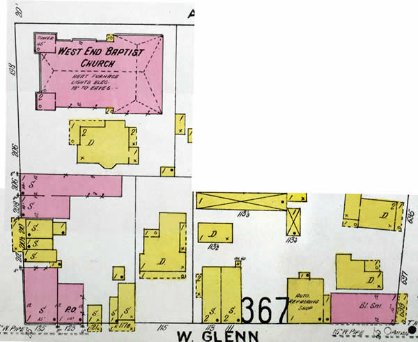
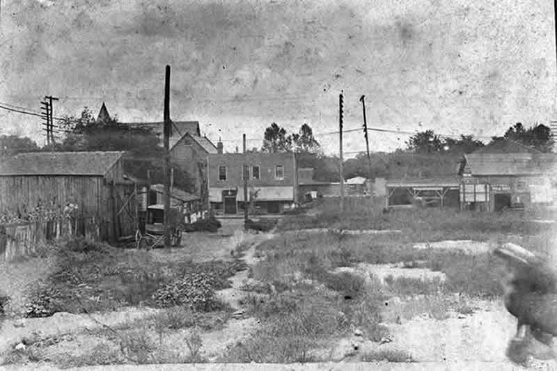
At the lower-right corner, you see the pink building labeled "Bl. Sm." It's a blacksmith shop, just where it should be. And to its left is . . . you guessed it, an "auto repairing shop." To the left of that is the two-story building. All of these are easy to identify in the photograph below.
The largest building here is the West End Baptist Church with its two steeples. You can see the church and the steeples in the photograph.
The city directory showed a U. S. Post Office at 123 Gordon. There it is on the map, identified with "P.O."
There's a bit of confusion about the address for B. D. Thomas. The 113 number apparently refers to his dwelling place in the two-story building. The blacksmith shop seems to face Whitehall Street, and has the number 699. No big deal. I still know I've identified the place in the picture.
I know where, but I don't know
why
Locating the site of the photograph
was a big victory for me, but I
still didn't know who took the
picture or why. I could not find
any links to my family in the map
or the picture.
The breakthrough
I kept looking at the map and began
to look beyond the row of buildings
to surrounding areas. And there
it was, right before my eyes.
My grandfather was here
Just south
of these buildings, across the
field seen in the photograph, is
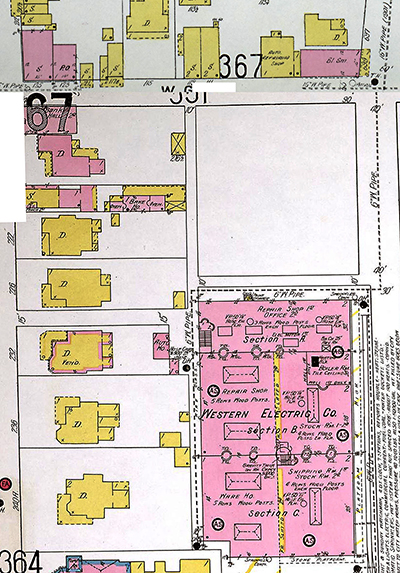
a large building. This is the Western
Electric building, where my grandfather,
John Allen Stephens Sr., worked
for most of his life. Some other
relatives also worked there.
In this reduced-scale picture, you can see the blacksmith shop near the top-right corner. Below that is the large open field. The buildings to the left of the field are visible in the photograph. This is where the buggy is sitting.
Just south of the lot is the large Western Electric building, and this is the location of the camera, aimed across the field toward the street. It captured the young woman moving across the foreground.
Because the picture was in my grandfather's possession, I think that he took the picture. Maybe he was trying out a new camera. Maybe he made the picture as part of his job. I don't know why, and I'll probably never know. But just a year ago, I thought I'd never know the location of the scene, and now I do.
Contact me at:

Last update: April 7, 2014