The mystery of the lost summer camp: part 4
Based on a freehand map in a Camp Highland brochure, I could see enough landmarks to locate the site of Camp Highland. It was northwest of Atlanta, wedged on a hilltop between a creek and a railroad.
This is a 1960 aerial photograph of Camp Highland. The railroad runs in a straight line from the upper-left to the lower-right. The dark area along the tracks is a deep cut through the rocky hillside. In the dark area, you can see a thin line—a steel foot bridge 30 or 40 feet above the tracks. Nickajack Creek is the horseshoe curve around the hill.

The light oval area near the center is an open field with a row of cabins along the left. They are barely visible as a row of five dots. To the right, a light rectangle is a concrete swimming pool. This open area was a gathering place for the girls, and is represented in many of the old photos, such as the one below. This is my aunt Elsie Stephens sitting on the base of the flagpole.

The row of cabins behind my aunt Elsie was torn down to build the swimming pool. The other row is not visible in this picture. In the early years, the girls slept in tents. Then two rows of cabins served as sleeping quarters. Later, there was only one row of cabins. This flagpole with its six-sided concrete base is an important clue in verifying the exact location of Camp Highland, as you'll see on the next page.
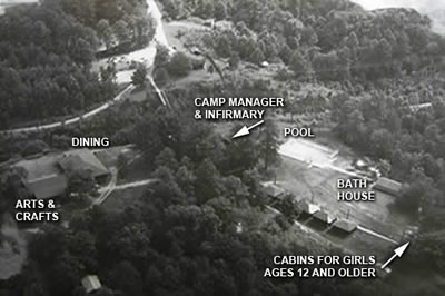
This low aerial shot shows the cabins and the pool in greater detail. Some of the other buildings are among the trees. The bridge across the tracks is near the top of the picture.

Contact me at:


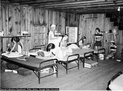
 This picture shows the girls inside
one of the several rustic cabins.
I've recently learned from a woman
who spent time at Camp Highland
that this is a two-story cabin
for girls aged 12 and older. These
cabins are labeled on the aerial
photo on this page. This picture
is from the 1950s or 1960s.